Map of Long Island
New York, USA
This map of Long Island is a good way to familiarize yourself with Long Island’s major areas. If you’ve ever heard people talking about the East End, the North Fork, South Fork, South Shore, etc. and weren’t sure what they were referring to then this is the map for you.
Because of its unusual shape Long Island can be divided into several distinct areas of interest, each one different than the others. In some cases the differences are significant.
Have a look at the map of Long Island below (click for big) and then continue reading for a brief description of each area. Or scroll down to the interactive map at the bottom of this page.
A Bird's Eye View
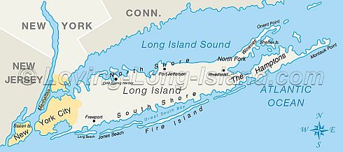
As with all maps north is up, south is down, east is right, west is left
The East End
You often hear people talk about the East End or how they went “out east.” Anything near or east of Riverhead is considered the East End of Long Island. The East End is made up of the North Fork and the South Fork. If you imagine that Long Island is shaped like a fish, the Twin Forks (as they are sometimes known) make up the tail.
The North Fork
The North Fork is Long Island’s agricultural center. The vast majority of Long Island vineyards are here as well as a large number of farms and orchards. Visit the North Fork for wine tasting, pumpkin picking, shopping, Greenport, Christmas tree cutting. This is the place to go when you want to drive out to the country.
The South Fork
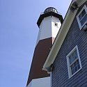
This is the Hamptons, Montauk Point, and the bulk of long Island’s Pine Barrens. Visit the Hamptons for endless shops, cafés, picturesque villages, celebrity spotting, etc... Montauk point for fishing, surfing, the Montauk Point Lighthouse.
Although it’s not shown on the map of Long Island above, you can travel easily between the forks via Shelter Island ferry. Pick it up in Greenport on the North Fork or Sag Harbor on the South Fork. The ferry runs every hour and you board with your car.
The North Shore
Characterized by stony beaches and tall bluffs the North Shore of Long Island faces Connecticut on the Long Island Sound. Business magnates of days long gone built their mansions on the North Shore, and the North Shore still attracts long Island’s wealthiest families, which is why it is sometimes referred to as the gold coast. Cold Spring Harbor is one example of a beautiful north shore town.
The South Shore
The South Shore is Long Island’s flat Atlantic coast and this is where you’ll find some of the best beaches in the world. Jones Beach, Robert Moses state park, and Fire Island are the major beaches on the South Shore and Freeport’s Nautical Mile is a great place for food, live music, and fun.
Although the word shore implies coastal, North Shore and South Shore actually refer to the areas north and south of the expressway (short for Long Island Expressway) extending to the coast.
Detailed Map of Long Island
Below is a more detailed map. Points of interest are marked with blue balloons. Click each balloon for more information about a specific place.
Use the [+] and [-] buttons in the upper left to zoom in and out. Click and drag to move the map around.
View Map of Long Island full screen (opens in new window).
So now you should have a pretty good idea of what Long Island is all about what it looks like, where the main attractions are, and how to get around. And, of course, I'll keep updating this page and the interactive map as time goes on.



New! Comments
Have your say about what you just read! Leave me a comment in the box below.